The Map They Hoped You'd Never Read
Editor's note: The map below is an official USACE permitted plan, a public document. We are publishing it in full because it contains information the Navigation District has never voluntarily placed before the public. Read the guide below it carefully.
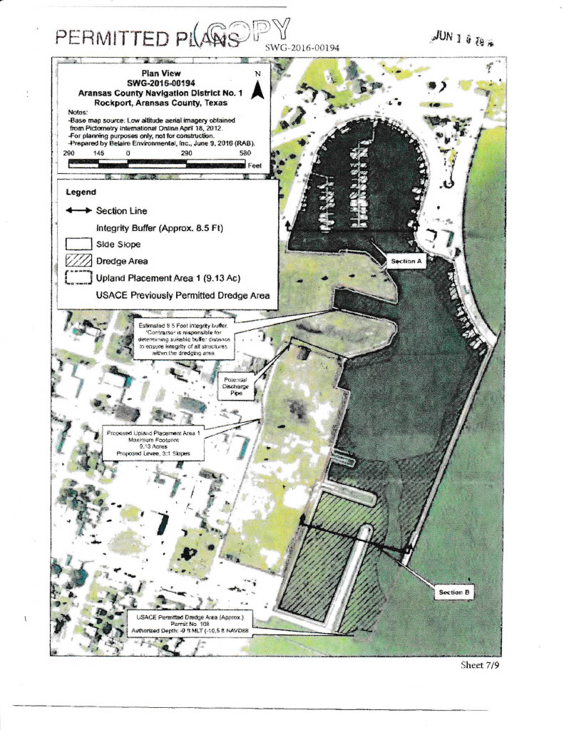
☠ Before You Look at the Map — Read This First ☠
🌊Dark Water = Deep water. Already there. Already fine.
🏖️Light Water = Shallow water. Almost no depth at all.
〰️The Striation Lines = Where the ground under the water starts rising up — like steps from the deep end of a pool toward the shallow end. These show real depth changes.
▨The Crosshatch Pattern = NOT a depth marker. This is the permit boundary — the area where the Navigation District asked the Army Corps of Engineers for permission to dredge.
🅰️Section A: The OLD Marina. Been there for decades. This is what they claimed was full of mud.
🅱️Section B = A BRAND-NEW area. Never dredged before. This is where almost all the digging actually happened.
💡The One Thing to Remember
Section A, the old Marina, is dark. Dark means deep. Already deep, before anyone touched it. If it were truly full of mud, they would have you believe it would be light colored, just like Section B. It is not. The crosshatch pattern on the map is simply where the District asked for permission to dig; the water color and striation lines are what tell you how deep it actually was.

▼ How to read this map — step by step ▼
Find Section A.Look at the right side of the map. See the white box labeled Section A? That is the original Marina, the part that has been there for decades, where local boats are docked. This is the area the Navigation District claimed was full of mud and dirt.
Look at the color of the water. Dark water = deep. Light water = shallow. Simple as that. See how the water around Section A is nice and dark? That means it was already deep — before anyone touched it.
Now look for the lines. See those diagonal lines spreading out from the east wall of the Marina, like ripples? Those lines show where the ground under the water starts to slope upward — where it gets shallower. They run along both sides of the channel coming into the harbor. Wind blowing in from the southeast for years pushed some sand and mud there. That part is real. But those lines stay outside the main Marina area. Note: the crosshatch pattern you see on the map is not a depth marker — it is the permit boundary, showing the area where the Navigation District was asking the Army Corps of Engineers for permission to dredge.
Follow the lines south — toward Section B. Now scroll your eye down the map toward the bottom. See how the water gets much lighter in color down there? That is Section B, a completely separate area near Market and Austin Streets. It was extremely shallow. Barely any water at all before the dredging. Average depth: less than 2 feet. A child could wade across it.
That crosshatch pattern? That is the permit boundary — not a depth marker. The diagonal crosshatch you see on the map marks the area where the Navigation District was asking the U.S. Army Corps of Engineers for permission to dredge. It is a legal boundary on a permit application, nothing more. The depth information comes from the water color and the striation lines, not the hatching. And what the water color tells you is that Section B was extremely shallow, barely 2 feet deep on average. A child could wade across it. The Navigation District wanted to dig it out to a depth of 10 feet to create a brand-new marina. About 90 to 95 cents of every dollar of dredging happened right here. Not in the old Marina. Not because of Hurricane Harvey. Not because of the City's drains.
So what did they tell the public? That the old Marina — Section A — was choking with mud caused by City drainage, and that the City owed them money for it. But the map you are looking at right now was made before Hurricane Harvey ever hit. The old Marina was already deep. The map shows it. The data proves it. And the District knew it.
The bottom line. They dug a brand-new marina, told everyone it was cleanup from a storm, and sent the City of Rockport the bill. The map in front of you, their own official document, says otherwise